IP Video System Design Tool
2024.0.0.2232IP Video System Design Tool: Design complex and modern video surveillance systems
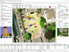
A reliable video surveillance system is designed to ensure the field of view for the monitoring devices is optimal and there are little to no unreachable areas. IP Video System Design Tool is a practical application that can help you make your video security system more reliable by performing various calculations and finding unreachable spots.The program can help you identify the best locations for the surveillance cameras using floor plans and taking the amplitude of their field of view into account. Site plans can be imported from Google Earth, Visio, or AutoCAD and set as backgrounds.
IP Video System Design Tool will factor in all the variables affecting the efficiency of your monitoring camera network. Users can adjust the location height, select the sensor format, as well as enter the camera's focal length and determine its tilt.
A 2D or 3D view of the camera's horizontal and vertical viewing angles can be generated so you can quickly identify blank spots. Support is provided for multiple camera resolutions from QVGA to 29MP Pro cameras. It's also possible to set custom resolutions that precisely fit your camera's specifications.
The software is able to estimate the disk space usage for recording archived and the required bandwidth which are needed to run the surveillance system. What's more, it can be exported as an XML or PDF file, as well as printed.
Download Details
-
License:
Trial
-
Platform:
Windows
- Publisher:
-
File size:
444.00 Mb
-
Updated:
Apr 20, 2024
-
User Rating:
0 / 5 (0 votes)
-
Editors' Review:
Not yet reviewed
-
Downloads:
3,396
Similar software
GPS Utility 5.51
Easily manipulate and map waypoints, routes and trackpoint information with this lightweight application
30 / 2,587
62 / 4,722